If this is what fell on the village there has to be more up top…
We have been asked for more detail on our daily Niseko snow report, if you’re interested then read on. If you’re looking for the daily snow report here’s the latest one.
Why are we doing it?
There’s a lot of talk about how much snow falls in Niseko within any given winter. There are figures that range from 12 to 18 meters but is that on the mountain or the village?
We wanted to know exactly how much falls on Hirafu village and for the 2011 and 2012 season we decided to find out by taking a daily reading, logging the data and taking a photo for reference.
Using the data and photos we collect we will make a time lapse video and an info graphic later in the season.
We thought some people might like the data for their own use and have made it available under a Creative Commons Attribution 3.0 Unported License, take a look at the bottom of any snow report for more detail.

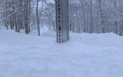
The daily snow fall depth photo, this one is from 1 December 2011
What are we doing?
Every morning (ideally before the lifts open) three different snow depth measurements are taken. One is from the snow station, which is 90cm wide and 178cm long with a meter ruler attached to it for the daily snow depth photo.
The other two depth measurements are taken directly from the same place on the ground in two different areas within a 5 meter radius of the snow station. We are taking care not to take the readings from any wind blown areas so we do not inflate the figures.
The three depth measurements give our daily mean average. As soon as the measurements are taken all the snow is cleared and the area is left until the following morning.

The snow station before any snow fell.
In addition to the snow depth we also log:
- Time the reading is taken
- Temperature at the time of reading
- Humidity at the time of reading
- The snow type
- An observational comment.
You can access all the data from this Google Spread Sheet. If you use it all we ask is that you link back to our website or credit 360niseko as the source of the data.
From when and until when?
The readings started to be taken on 15 November 2011 when the first snow settled on Hirafu village (at 250m elevation) and will continue to be taken daily until the end of March 2012. If it snows on any day in April or May we will log the data and also publish a report.
Other things
To keep the report fresh we will add at least three photos from that morning or the day before, sometimes we may swap this for a video or something else. If there’s something you want to see let us know and we will try and add it for you.
Everyday there’s something interesting happening in Niseko, and to keep you in the loop we add a few notes to the report. We also nominate our ski run or two and who we will be riding with that day.
Next season?
We might get a bit more technical next season and mix things up a bit with new ideas. But we will continue to take the same readings using the same instruments to keep it consistent and allow us (or you) to compare annual differences.

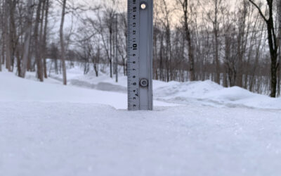
The snow station on 10 December 2011
Final thought
What happens when one meter or more dumps on Niseko within 24 hours?