Even More Blue
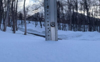
*5.1cm of fresh snow has fallen since yesterday morning and at 7:15am today the temperature was -13°C.A beautiful morning here in Niseko and the clear conditions look set to continue through the day.

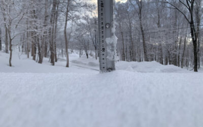
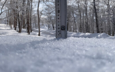
Snow fall depth in Hirafu village, 31 January 2012
Useful information from other places
- Snow depth at the peak, 375cm
- Snow depth at the base, 200cm
- JMA’s six hour precipitation forecast, possibly the most accurate weather map
- Real time lift operations.
- The latest Niseko avalanche report.
What’s happening today
It’s not often that we get so many January blue bird days in a row – or even in a season – here in Niseko, so get out there and enjoy it while it lasts.
Today we will head over to Moiwa to catch some speedy groomers and with some luck a few untouched powder stashes.
The Expert Run is recognised by the Ski Association of Japan as a giant slalom course so if you want to test your high speed skills, this is the place.
Moiwa’s Main Burn runs is nice and wide allowing for plenty of space to lean into some big turns while taking in the beautiful view.
Shirakaba Slope is where the deep powder will be found. There’s a myriad options riding down this course with it’s well spaced Silver Birch trees, so you can easily spend a good session riding new paths.
Rooftops
An endless source of interest and amusement is the patterns and shapes snow makes as it accumulates on the roofs of buildings.

Snow piling up on the roof

A day after clearing or not

Hirafu roof top #3, 30 January 2012

Hirafu roof top #1, 30 January 2012
Snow Forecast
Get more information on Snow-Forecast.com.
Niseko snow fall data
The 360niseko snow fall data is licensed under a Creative Commons Attribution 3.0 Unported License. Feel free to use it for personal or commercial purposes and if you publish it please credit 360niseko by providing a link back to the website.