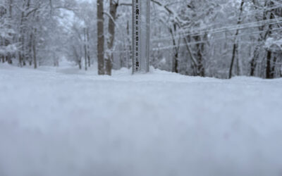
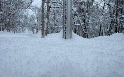
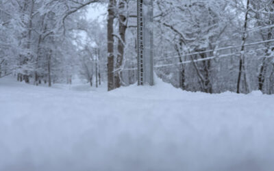
*0cm has fallen in the last 24 hours in Niseko. At 6:22 am today the temperature was 1.7 °C.
So some interesting news this morning. If you scroll down you will see a bit of a new feature … a live cam!!! Thanks to the good folk at Rhythm we now have a live view of Hirafu Zaka under the report so you can see the snow falling any time of the day. Today you may see the odd car or mother clinging to a pram blow past as it’s windy outside and the low pressure in the sea of Japan is spinning hard. It’s also a good bit colder than the positive figures of yesterday and the rain event. We would recomend keeping a close eye on the avvie report cross the next day or so there is a SOLID rain layer in the snow pack (We will hence forth know it as the Dec10 Demon) with graupel sitting ontop of it and that makes the dream base for a slide.

Snowfall in Niseko, 12 December 2017
Useful information from other places
- Accumulative snow fall to date in Niseko, 323cm
- Snow depth at the peak, 215cm
- Snow depth at the base, 80cm
- Real time lift operations.
- JMA’s six hour precipitation forecast, possibly the most accurate weather map
- Snow Forecast 6 day weather summary
- The latest Niseko avalanche report.
- Please follow the Niseko Rules.
Live Web Cam from Hirafu Village
Snow Forecast
360niseko Snow Station Readings Disclaimer
The 360niseko now has 2 snow stations for the 2017-18 in Higashiyama at 200m and 300m *The Hirafu Gondola is at 305m. Please be aware that this new reading is NOT in Hirafu village but a few kilometers down the road. There is always a deviation how and where the snow falls – the area is famous for micro climates and mini weather patterns. Some days there may be 10cm in Annupuri and 25cm in Hanazono and vice versa – some days 30cm of fresh snowfall comes down everywhere!! Altitude plays a big part as well so please don’t take the 360niseko snow readings as being definitive – the readings are what is outside our houses on the ground.