Deep and Dry
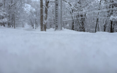
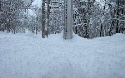
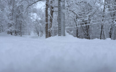
*20.5cm of fresh snow has fallen since yesterday morning and at 6:50am today the temperature was -8°C. Winter has returned after the warm conditions earlier in the week and this morning the snow was the lightest and driest i have cleared off the snow station this year.

Snow fall depth in Hirafu village, 16 February 2012
Useful information from other places
- Accumulative snow fall to date, 1,266cm
- Snow depth at the peak, 410cm
- Snow depth at the base, 220cm
- JMA’s six hour precipitation forecast, possibly the most accurate weather map
- Real time lift operations.
- The latest Niseko avalanche report.
What’s happening today
Today we will ride Niseko Mt Resort Grand Hirafu queue up for the first Hirafu Gondola at 8:30am and then hit Miharashi where we will surely find epic turns before running out on the lower section of Holiday and then put in a few quick turns in on the freshly groomed Boyo run as we make our way back down to the Hirafu Gondola.

Hirafu Gondola lift guide, 16 February 2012
It will be worth keeping an eye out for higher lifts opening as the morning progresses.
Deep turns
Today we are expecting exceptional conditions on the mountain where there should be huge chunks of pow flying everywhere!

Classic deep turns in Hirafu, 26 Jan 2012
The deep pow makes being on the mountain a dream and is also pretty forgiving.

Hiking back for one more hit in Hanazono, 8 February 2012

In the deep niseko snow you can land pretty much in any position, 8 February 2012
Have a great day on the mountain.
* Update * during the writing of this snow report between 7:00 and 8:00 i was amazed to find an accumulation of 10+ cm’s on my car when i went outside to head up to the lifts. This morning was one of the heaviest dumps i have ever seen – the snow was coming down so hard that it was difficult to see the Alpen Hotel from center 4 and there was no wind at that altitude! Here are a few pictures although they don’t quite do the snowfall justice!

Hirafu Ace Quad Lift #2 Center 4 - first lifts, 16 February 2012

Hirafu Ace Quad Lift #2 Center 4 - 'chillaxing' before the first lifts, 16 February 2012

Hirafu Gondola during heavy snowfall at 8:35 this morning, 16 February 2012
Snow Forecast
Get more information on Snow-Forecast.com.
Niseko snow fall data
The 360niseko snow fall data is licensed under a Creative Commons Attribution 3.0 Unported License. Feel free to use it for personal or commercial purposes and if you publish it please credit 360niseko by providing a link back to the website.