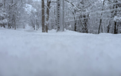
*0cm has fallen in the last 24 hours in Niseko. At 7:00 today the temperature was -1°C. Freeze thaw conditions. Although there isn’t an accumulation on the 360niseko snow station we did have a sweet layer of fresh snowfall come down yesterday…it just didn’t last at lower elevations. Higher up it should have been a bit of a top up. With heavy snowfall predicted for tomorrow fingers crossed we will all be checking into the white room shortly – HAI!

Snowfall in Niseko, 22 December 2016
Useful information from other places
- Accumulative snow fall to date in Niseko, 274cm
- Snow depth at the peak, 210cm
- Snow depth at the base, 80cm
- Real time lift operations.
- JMA’s six hour precipitation forecast, possibly the most accurate weather map
- Snow Forecast 6 day weather summary
- The latest Niseko avalanche report.
Snow Forecast
360niseko Snow Station Readings Disclaimer
The 360niseko snow station is now in a new location for the 2016-17 between Hirafu and Higashiyama at 200m in altitude. There is 27m difference in altitude to last seasons position in lower Hirafu village 227m. *The Hirafu Gondola is at 305m. Please be aware that this new reading is NOT in Hirafu village but a few kilometers down the road. There is always a deviation how and where the snow falls – the area is famous for micro climates and mini weather patterns. Some days there may be 10cm in Annupuri and 25cm in Hanazono and vice versa – some days 30cm of fresh snowfall comes down everywhere!! Altitude plays a big part as well so please don’t take the 360niseko snow readings as being definitive – the readings are what is outside our house on the ground.